Aiming For The Sky
Geophysical surveys are something you do not often hear about. But without them, exploration of natural resources would be close to impossible. A geophysical survey is a key process of measuring the variation in several key physical or geochemical parameters of the earth. This helps with mapping of subsurface areas to detect mineral resources for exploration or archaeological sites. It is more like putting the ‘X’ mark on a map marking the spot where the treasure lies.
One such firm that excels in this industry and are leaders in the Canadian market is Montreal-based firm EON Geosciences Inc. EON Geosciences specializes in airborne geophysical surveys with over four decades of experience behind them. They are known mostly for their high quality services with cutting-edge technology and rigorous safety and quality control procedures. EON Geosciences caters to both public and private sectors providing clients with results of high precision mapping for mineral, uranium, diamond, oil, and gas exploration.
Airborne geophysical surveys are a cost-effective and optimal way of securing geophysical data to test the ambient magnetic fields of a widespread area in the search for a broad spectrum of commodities. They provide a broad overview of the geology of a particular area, as well as measure the fluctuating magnetic signatures found in the Earth’s crust that may be indicative of mineral concentrations.
Speaking on the origin of EON Geosciences, president of the company, Khaled Moussaoui, tells us that before EON Geosciences came into being, his father had started a firm called SIAL Geosciences in the late 70’s that began with land surveys and soon went into airborne geophysical surveys. After over 20 years of operation, Khaled’s father was approached by one of the major companies in the industry that was keen to buy SIAL Geosciences. Khaled’s father, who was also considering retirement at the same time, saw it as an opportunity. So the deal was done and the company was sold.
Six years later, as Khaled puts it, his dad wanted to “get back into the action”. Khaled was back in Montreal after having worked six years in Boston and wanted to be a part of his dad’s dream. After a few deliberations, the father and son team collaborated with a third partner and EON Geosciences was born. It was incorporated in January 2007. New equipment was purchased; they bagged their first deal in the spring of 2007 and began work that summer.
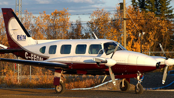
EON Geosciences currently owns three aircraft: a Piper Cheyenne II, a Piper Navajo, and a Cessna 206. All aircraft are modified with tail stingers and wing-tip pods to hold their high-tech equipment that comprises of magnetometers, spectrometers, dual frequency GPS receivers, data acquisition systems, video cameras, and other equipment to enable the acquisition of high precision data.
Speaking on how it actually works, Khaled explains: “We fly over survey areas that are usually defined by our customers — the location of the survey and the flying specifications they require. Then we prepare a flight plan.”
“All flight lines are predetermined and are entered into a navigation system onboard. The aircraft or helicopter pilot has to use the navigation system to follow the flight lines and terrain as closely as possible” Khaled said. Back at the office, the team processes the data (such as the positional data from the GPS systems), cleans up the model, and provides customers with the final data. EON Geosciences also creates maps, provides the video from the flight, and presents a final report in both electronic and paper formats, according to Khaled. Khaled says magnetic surveys are the most commonly employed method of airborne geophysical surveys as magnetics are commonly used in conjunction with each of the other technologies.
“In a magnetic survey, a magnetometer is attached to an aircraft in either a stinger or boom which provides distance from the aircraft itself. The boom helps minimize undesired measurements due to magnetic elements on the aircraft,” explains Khaled. The magnetometers measure the magnetic fields in their current state, as magnetic fields are in constant flux as they are dependent upon spatial variations and solar winds.
EON’s airborne surveys come equipped with a wide assortment of technologically-advanced instruments to enhance the survey data, tailored to the client’s needs. Airborne surveys are not only faster and more time-efficient than other forms of surveying, but they also allow for greater terrain coverage.
Helicopter-borne surveys fly at reduced speeds and altitudes, which offer greater data density and higher resolution. The results are detailed yet precise terrain mappings suited to the client’s needs and requests. EON Geosciences undertakes surveys of different types, namely magnetic, gamma-ray spectrometric (radiometric), gravity, and electromagnetic surveys. Each kind of survey sensor is unique in the type of information it gathers and also in how each survey must be performed. For example, magnetic data may be acquired at a higher altitude and aircraft speed than radiometric which requires a low and slow flying aircraft for superior data. Detailed surveys are done for the specific target identification reasons of direct or indirect prospecting. A direct prospecting survey is done to gain perspective on the concentrations of magnetic ores such as kimberlites, magnetic iron ores, and chrome in a specific area. The mining industry relies on aeromagnetic surveys as a means of uncovering high concentrations of such minable commodities, which are reflective in the magnetic fields found in the space above the land.
While most of EON Geosciences’ clients are mining and oil companies, their two high profile clients have been Natural Resources Canada and the Quebec Ministry of Natural Resources. EON Geosciences is also working with the U.S. Geological Survey. EON Geosciences have undertaken several projects for uranium exploration in Canada, “Uranium has been big in Canada” Khaled said. On EON Geosciences’ future plans, Khaled says right now their immediate expansion plans are to enter the South American market. “We are hoping to begin work in South America later this year” says Khaled. EON Geosciences is also looking at fleet expansion as they venture out into new markets. “Within a few years, EON Geosciences hopes to be flying internationally in several continents with a larger fleet of aircraft, equipment, and personnel” Khaled says. “We also hope to do some of our own research development and develop new techniques and ideas with the equipment and technology that we use.”
Besides eyeing markets in Africa, the Middle East, and Asia, Khaled sees EON Geosciences as a global leader in the airborne survey industry and an expansion into marine and ground surveys in the future might perhaps even be possible. “We aim to stand out among our competition as our research and development team continuously works to improve and enhance equipment and technology to give our clients the best at a lower cost,” quips Khaled.
With a dedicated team and proven results, EON Geosciences has achieved a lot in the past five years since its rebirth. At the pace they are moving, it will not be long before they attain their goal of having their geophysical footprint all over the world.