Crafting Revolutionary Technology For Space and Earth Explorations
By Rajitha Sivakumaran
Click to view Brochure
Vast and enigmatic, space has incited a considerable amount of fascination despite being an impossible destination for the average Earthling. Everything from ancient astronomy to modern-day extraterrestrials demonstrates our fixation with the boundless extension of our skies, but only a few devote their lives to studying the mysteries of space. In the Canadian context, Dr. Jean de Lafontaine is one such example.
President of NGC Aerospace and a professor with the Université de Sherbrooke’s faculty of engineering, Dr. de Lafontaine’s fascination with space exploration has only intensified with time. He founded NGC in 2001 and since then, the company has been making mobile vehicles autonomous and intelligent, employing breakthrough technology that has revolutionized the aerospace industry.
With NGC’s technology, these vehicles rely less on human intervention or interaction. With the exception of complex decision-making and high-level monitoring, something humans are very good at, these vehicles can function independently. Software is the backbone of this artificial intelligence. Dr. de Lafontaine and his staff develop the code that goes into a computer, which in turn runs and manages the movement of various means of transport in space.
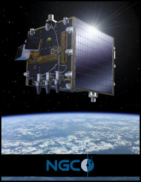
The first type of vehicle NGC worked on was the satellite. Presently, there are four satellites (PROBA-1, PROBA-2, PROBA-V and Sentinel 3A) in orbit that exhibit a high level of intelligence due to the company’s technology.
Traditionally, the successful operation of a satellite depended on ground operators. A long list of commands was prepared made, and calculations were done on ground and sent to the satellite days in advance. The satellite then read these commands and executed them in a dummy fashion. NGC ended this type of satellite when it put all of the intelligence of ground operators into a software onboard the satellite. Referred to as the Attitude Control and Navigation System (ACNS), the software allows for autonomous navigation, guidance and control of the vehicle. The implications of this are mind-blowing — the satellite can orient itself using celestial bodies like stars. It now knows which country it hovers above using GPS satellites.
“If you ask the satellite to take a picture of Montreal, then it knows the geographic coordinates, it knows when it will be flying over Montreal and in what direction with respect to the sun and with respect to the satellite. It takes the picture autonomously and then sends it to the ground operator,” Dr. de Lafontaine said.
The ground operator now has very little to do. In fact, even when anomalies occur, the satellite will try to repair itself. This increases the efficiency of the mission and reduces the number of people required to operate the satellite on ground. As a result, the ACNS has reduced the cost of operating a satellite.
The use of this technology has been extended to planetary exploration as well and plays an essential role in NGC missions involving Mars exploration and moon landings for the Canadian and European space agencies. For instance, navigation systems have been developed for rovers used to patrol Mars and the moon. Rovers can now depart from the lander for exploration purposes with the ability to return to it at a later time.
Presently, NGC is working with the European company, Airbus, to land a robotic satellite on the lunar South Pole. NGC will be designing the landing system, a software called the Autonomous Planetary Landing System, that will guide the satellite, detect obstacles, judge the level of danger on a site and autonomously decide where to land safely.
On previous missions to the moon, astronauts were on board to select landing spots. During Mars explorations, vehicles were landed in large, open valleys, far away from iconic and dangerous landmarks like craters. For future missions, however, scientists want to land closer to features like the rim of a crater for further examination. The problem is that photographs of landing spots taken from orbiting satellites during earlier missions have limited resolution; smaller hazardous surface material like rocks aren’t visible. “As we get closer to the surface during landing, our software detects that with all kinds of sensors and then avoids them autonomously and finds the safest place to land,” Dr. de Lafontaine said.
The company is also involved with the newest satellites in the PROBA series, PROBA-3. The preliminary studies and designs have been completed and NGC is currently developing the software. The unique thing about this project is that it consists of two satellites that will fly in formation, that is the two satellites will coordinate themselves in terms of orientation and relative position to achieve a mission. The satellites’ mission will be to observe the sun; one will hide the sun disk while the other will examine the external part of the sun for eruptions.
The importance of this monitoring system is needless to say; solar eruptions is a popular theme in doomsday movies and the havoc they can wreak on Earth is universal knowledge. Accordingly, once launched, PROBA-3 will be used to detect eruptions.
A little closer to Earth
Here on Earth, NGC is involved in aerial-terrestrial systems and projects have centred on unmanned aerial vehicles (UAVs) and unmanned ground vehicles. At this time, along with other industrial and university partners, the company is developing an unmanned helicopter, which will be used for various applications: the agricultural industry can use it to see where irrigation is required or survey the fields; infrastructure like bridges can be monitored and inspected for safety; in forestry, the best trees available for cutting can be identified.
The same technology used on Mars and the moon for obstacle avoidance are now being applied to Earth-bound vehicles. NGC is equipping UAVs with on-board intelligence, a ‘sense and avoid’ system that perceives the environment around the UAV and ensures that it does not collide with the object that it is surveying. An electronic bumper is created; if the operator either accidentally or voluntarily brings the drone too close to an obstacle, this invisible bumper overrides the manual commands.
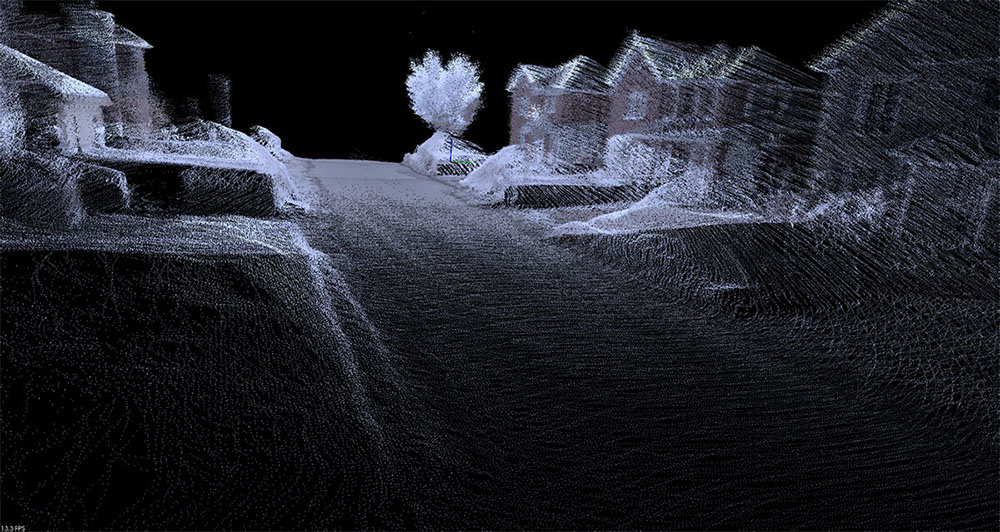
An add-on feature to UAVs is the three-dimensional mapping system that NGC has developed. “A drone plus a mapping system, I think, makes a very neat combination,” Dr. de Lafontaine said. The reconstructions reflect the real thing in shape, colour and texture. GPS coordinates are incorporated into the three-dimensional computer images, so that measurements and volume assessment can be taken with a mouse.
The system is particularly useful for site preservation whether it be a crime scene or the location of a large-scale calamity. For example, if a train derails, the investigator has to reconstruct the scene. On the one hand, the police want to assemble the evidence and preserve the scene. On the other hand, cleanup is required in order to minimize chemical leakage. With the drone-mapping system duo, a three-dimensional depiction with GPS can satisfy both demands.
In regards to natural disasters, Dr. de Lafontaine has proposed an idea to the Canadian government to observe and detect forest fires using satellites. Initially called the Platform for the Observation of the Earth and Technology Experiments (POETE), it became the Canadian Wildland Fire Monitoring System. It will eventually consist of a constellation of satellites with the objective of detecting and tracking forest fires mainly in Northern Canada. Once the fire is detected, the directions of both the fire and the smoke can be predicted and danger areas can be foreseen, making evacuations more efficient. The project is presently in the planning phase and could become a viable commercial system if Canada decides to provide detection services for other countries prone to forest fires.
www.ngcaerospace.com